Table of Content:
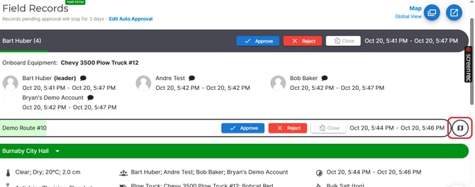
Global Map (Dispatch Page)
Purpose
The Global Map provides a live, system-wide view of all crew members, routes, and sites. It’s the best way to monitor daily operations in real time.
Accessing the Map
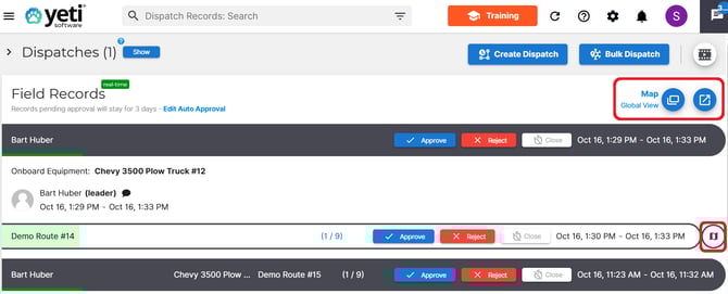
Select the Map button on the Dispatch page to open one of the available map views:
- Map Pop-Up: Opens a small map view directly within the Dispatch page.
- Map in New Browser: Opens a full-screen map in a new browser tab.
- Route Map: Displays map data related only to a specific route.
Key Features
- Live Crew Tracking: View real-time locations of all crew members in the field.
- Route and Site Status: See the current progress of routes and individual sites.
- Map Views: Toggle between Terrain and Satellite view.
- Filtering: Use the Search Filter button to display only the sites or routes that meet certain criteria.
- Zoom Controls: Use the + and − buttons to zoom in and out of the map.
- Color-Coded Site Pins: Easily identify service types and statuses using the color-coded pins.
- Legend: A map legend in the bottom-left corner explains pin colors and completion status.
Best For:
Dispatchers who need a real-time, high-level view of all operations.Route Map (Dispatch Record)
Purpose
The Route Map allows you to track a crew member’s movement from the start to the end of their shift. It focuses on a single route and provides detailed activity tracking.
Key Features
- Crew Movement Tracking: Follow a crew’s path as they complete their assigned route.
- Detailed View: Zoom in to see specific movements and actions at each site.
- Multiple Crew Tracking: If multiple crew members are working the same shift, you can view them simultaneously.
- Action Markers: Black dots represent specific actions (e.g., starting or completing a route). Click a dot to view action details.
- Mobile Tracking Integration: Works when crew members have the Yeti mobile app installed and have enabled location tracking.
Supervisors and managers who need to review a specific route or crew’s shift activity.
Route Builder Map
Purpose
The Route Builder Map is used when creating or editing routes. It helps visualize stops, optimize efficiency, and ensure accuracy before dispatching.
Accessing the Map
You can access this map when creating a new route.

Key Features
- Add or Rearrange Stops: Drag and drop locations directly on the map.
- Automatic Distance and Time Estimates: Get instant travel estimates as you adjust routes.
- Route Optimization: Preview and fine-tune route efficiency.
- Map Layers: Switch between standard, terrain, and satellite views.
Best For
Planners who need to build and adjust routes before sending them out to crews.
Weather Report Map
Purpose
The Weather Report Map overlays real-time and forecasted weather data to help you plan routes around weather conditions.
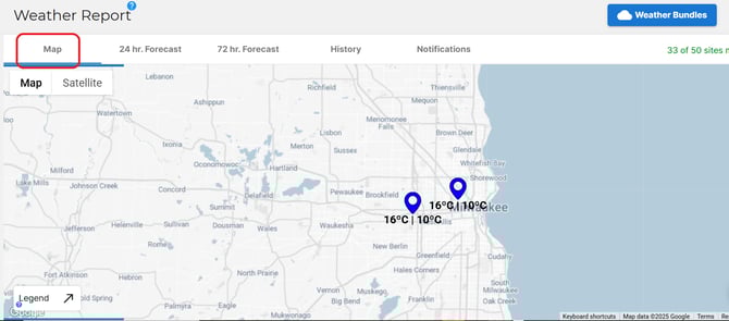
Key Features
- Live Weather Layers: View precipitation, temperature, and storm activity directly on the map.
- Route Overlays: Visualize how current or forecasted weather may impact specific routes.
- Forecast Tools: Check upcoming conditions to adjust schedules or resources.
Best For
Teams planning routes or shifts that may be affected by weather.Route History Map
Purpose
The Route History Map allows you to review completed routes and analyze crew performance.
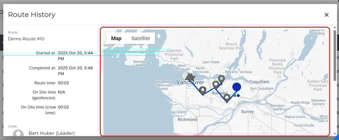
Key Features
- Playback Controls: Replay the entire route to see where crews traveled and stopped.
- Stop Details: Click on any location to view timestamps and service information.
- Deviation Tracking: Identify areas where crews went off-route.
- Performance Review: Compare planned vs. actual routes for efficiency insights.